Los alerces national park


, Chubut, Argentina
Suggest Place to Visit
265
Track to location with GPS |
 |
It was created in 1937 and has an area of 263,000 ha. The foundation of its creation is the protection of the forests of lahuán el alerce, one of the longest-lived trees on the planet, which will be in danger of extinction.
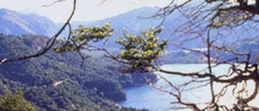
The protected area environments can fit into the ecoregions of the Patagonian forest and the high Andes, and opt for a cold temperate climate, with a great season. The rainy and rainy winter, the dry summer, the cool night. In the area there is a complete lake system with numerous rivers, streams and water spills.
The geographic center of this Argentine National Park is located at coordinates 42 ° 50 and 8242; 00 and 8243; S 71 ° 52 and 8242; 00 and 8243; O and 65279; / e 65279; -42.833333, -71.866667.
Approximately 4,000 mm of annual precipitation make this region one of the poorest Andean-Patagonian forests in vegetation: the Valdivian forest. In this environment the lahuán is distinguished, a gigantic conifer that at the beginning of the 20th century was on the verge of disappearing due to uncontrolled exploitation. The Argentine Patagonia has the privilege of having one of the oldest and densest forest formations of this ancestral species, still considered sacred by indigenous settlements. On the sides of Lake Menéndez, the majestic and beautiful buildings have an estimated age of 4,000 years and reach 75 meters in height and 3.5 in diameter.
The eastern basin, the transition with the steppe, marks less lush forests from where the maitén and the mountain cypress trees grow. Also radales, arrays, ñires, lengas and maquis cover the mountains and make up a landscape of incredible beauty colored by rivers and lakes.
The exotic flora, betrayed by the European settlers, represents in this National Park a serious problem to conserve the native vegetation. Rose hips, lupine and daisy, among other plants, began to disperse unaided along the edges and clearings of the forest, clearing the originals.
Likewise, illegal logging and fires prevent the recovery of different species of trees that are slow to grow and cover the slopes, favoring erosion.
In addition to nurturing birds such as the chucao, the Patagonian black woodpecker, the pythio, the caburé, the southern cape and the Patagonian forest, Los Alerces National Park is a refuge for many endangered species such as the pudu, the Araucanian pigeon, the huiña cat . , huillín and mainly huemul. This native Patagonian from Patagonia can be seen on the Riscoso hill, declared a critical area for the conservation of the species.
As in other Patagonian parks, introduced species, such as the red deer, the red deer, the wild boar and the deer, have a serious impact on the forests. For this reason, a system of protected areas with limited extraction is also allowed in this protected area. The view was introduced between 1945 and 1960 to supply the local pedestrian market, mainly in Cholila, a town located northwest of the National Park. In the 1970s, several were released and multiplied, dispersing throughout the pre-Andean region of Chubut and Río Negro. Of carnivorous habits, the sight attacks children and adults of birds and terrestrial or aquatic mammals, endangering the native fauna. Likewise, the puddles are attacked by asylum seekers. The furtive cage is in danger for both the huemul and the puma, precious and exemplary for the dogs.
There are numerous rivers, lakes and ponds, waterfalls, and high-altitude glaciers. The park contains a set of 9 lakes such as Futalaufquén, Menéndez, Rivadavia, Krügger, Verde, Swan, Stange, Chico and Amutui Quimei, the latter being a package originated by the Futaleufú dam, some of these lakes are connected by several There are numerous rivers , lakes and lagoons, waterfalls and glaciers at high altitude. The park has a set of 9 lakes such as Futalaufquén, Menéndez, Rivadavia, Krügger, Verde, Swan, Stange, Chico and Amutui Quimei, the latter being a package originated by the Futaleufú dam.
Los Alerces National Park is a protected area of 263,000 hectares located in the Cordillera region of the Province of Chubut, on the international border with the Republic of Chile. It was created in 1937 with the fundamental objective of protecting the forests of Lahuán el alerce, a typical exponent of the Andean-Patagonian flora.
The protected area environments may fit into the ecoregions of the Patagonian forest and the high Andes.
In the area there is a complete lake system of numerous rivers, streams and discharges, which make up a system that stands out in the Menéndez, Rivadavia, Futalaufquen and Krüger lakes, and the Frey river that flows into the Futaleufú hydroelectric dam (Amutui Quimey package).
The first inhabitants of the region settled 3,000 years ago in the Desaguadero river valley. Waste collectors. They used animal shapes and stones to make boleadoras, arrowheads, nails for sewing leather, and metal artifacts. In this way, he appreciates the environments of the lakes and the forest.
These populations used the eaves walls as support for the realization of cave art paintings. The main motifs expressed in these sound sites: concentric, cruciform, rectangular circles, labyrinths and schematic human figures. These are similar to those found in northwestern Patagonia.
The descendants of these settlements moved to the Tehuelches and Araucanas communities, which, thanks to the Spanish, began to change their way of life. They incorporated new food and productive resources, including the horse, producing transformations, such as the largest movement of groups.
The effects of the Desert Campaign (1879-1883) led to its dismantling. At present, Mapuche families live in towns near the National Park.
WALKS AND SERVICES
In Villa Futalaufquen, within the Park, there is the Intendancy and the Information Center and Museum, here you can obtain information and acquire fishing permits. The place has a service station, phone booths, restaurant, grocery store, free, wild and organized campsites, cabins and inns.
You can get to know the park through more than twenty pedestrian paths and numerous vehicular paths. Mandatory registration trails at the Information Center:
The Cinco Saltos Trail: starts at 1,500 m passing Puerto Bustillo, it will take you to the viewpoints of the Los Pumas stream waterfalls. It has a medium difficulty and lasts for 3 hours.
Cerro Alto El Dedal Trail: lunch 200 m from the information center and ends at a viewpoint at the top of the hill, from where you can see part of Lake Futalaufquen, Cordón Situación and the Desaguadero River Valley. It is difficult to get up and lasts 7 hours.
Road to Lake Krüger: lunch in Puerto Limonao and ends at Lake Krüger, where camping is allowed. It has a high difficulty and lasts 12 hours.
Path to the waterfall: lunch 200 meters from the Information Center and make a circuit along the side of this Cordón Situation, passing through several viewpoints. It has a medium difficulty and lasts for 4 hours.
Mandatory registration tours at Arrayanes Lago Verde Sectional Park Rangers:
Sendero a la Laguna Escondida: lunch in front of the section of Arrayanes guardparks and culminates in the Laguna Escondida. This media difficulty lasts 3 hours.
Path to Cerro Alto el Petiso: you eat from Pto. Mermoud, the lagoons of Lago Verde and you reach the top of the hill. It has a medium difficulty and its duration is 6 hours.
Routes that do not require registration:
Cave Paintings: It is located 1,200 m from the Information Center. It has a low duration and its duration is 30 minutes.
Puerto Limonao: it is located 650 meters from the Information Center, making a 4 km journey through the forest, between Lake Futalaufquen and the route. It has a short duration and a duration of 2 hours.
Lake excursions: You can hire a lake excursion that sells from Puerto Limonao (4 km from Intendencia) and departs from Lake Krüger and Puerto Mermoud. In this, you can go down to the short section to Puerto Chucao, from where you take another boat that crosses the Menéndez lake, bordering Isla Grande and later you can enjoy the Torrecillas Glacier. Then you travel to Puerto Sagrario, on the North Lake of the same lake, from where, through a circuit of medium-low difficulty, of 1 hour and medium duration, you can see the ´´Alerzal´´.
Puerto Chucao can also be accessed by crossing the Arrayanes river pass, to use an interpretive trail of 1,500 m, in which there are dangerous trails.
To access the National Park it is necessary to go to the city of Esquel. from there, along National Route No. 259, connecting with Provincial Route No. 71 that crosses the protected area in a north-south direction. This route leads to Villa Futalaufquen, from where the administrative center of the National Park is located.
The route continues towards the north of the Park, joining Villa Futalaufquen with National Route No. 258, bordering the city of El Bolsón.
The city of Esquel has an airport (38 km from the National Park) and a bus terminal, which offers greater possibilities of access to the protected area.
Los Alerces National Park is a large protected area located in the Province of Chubut, Argentina. Embrace Lake Futalaufquen, Arrayanes River, Green Lake and Menéndez. Due to its incredible landscape, it is considered one of the most beautiful parks in Argentina.
Comments
We don´t have yet any comments about:
Los alerces national park
Los alerces national park
Be the first to leave a comment as it is very important to inform other people
Outros locais a visitar
Within a radius of 20 km from:Los alerces national park
Unfortunately we do not have information on other places to visit in this area yet
Hotel reservation near Los alerces national park within a radius of 20 km
Why to book with ROUTES TOURISTIQUES
The best prices
Our partnerships with the world´s largest operators offer research on the best market prices.
More options
At Rotas Turisticos you can book the hotel, buy the air ticket, book the transfer from the airport to the hotel and vice versa, book the local excursions, rent the car, take travel insurance and consult the places to visit and where to go.
Holiday Tips & Destinations
Hundreds of holiday destinations with all the options that allow you to easily choose the destination that best suits your dream vacation.
ROUTES TOURISTIQUES
Links
Follow us on social networks


